On this page: Introduction | Acoustic Monitoring for Birds and Bats | Visual Imaging Surveys | Game Cameras
![]()
Historically, documenting animal presence required in situ visual observations, often involving costly, labor-intensive field efforts. Over the last few decades, technological advances have made it possible to remotely detect animals with tools, such as autonomous recorders units (ARUs), camera traps, and unoccupied aerial vehicles (UAVs), that can serve as our eyes and ears in the field. These devices allow data to be collected for longer durations across larger areas, leading to a more comprehensive understanding of wildlife populations for often a fraction of the cost of a boots-on-the-ground effort. Using remote monitoring tools to detect birds, bats and marine mammals has become a standard survey practice for commercial projects to achieve compliance under the National Environmental Policy Act (NEPA), Endangered Species Act (ESA) and the Marine Mammal Protection Act (MMPA).
 At BRI, our team of biologists has expertise in using remotely deployed devices to survey for waterfowl, marine, wading, and shorebirds, as well as bats and marine mammals, from the deployment and retrieval of devices, to the processing, analysis and reporting of data. We have worked with a variety of partners using wildlife remote acoustic and imaging approaches to help monitor species presence, behavior, and distribution and meet various compliance needs.
Acoustic Monitoring
Many animals produce sound for communication and navigation, from birds and bats to marine mammals and fish. By doing this, they broadcast information about themselves into their environment. Acoustic sensors provide a useful way for ecologists to capture this information and to survey wildlife populations, animal behavior and ecological communities. Acoustic monitoring provides opportunities for increased data collection and species detection because of the ability to monitor wildlife in hard to access habitats.
Birds
BRI has over a decade of experience utilizing acoustic monitoring to better understand avian distributions and abundance across the U.S. Past projects include monitoring of breeding birds, migrant birds, both onshore and offshore, as well as assessments of secretive marsh birds, and species-specific studies. Future research includes using acoustic monitoring to monitor the response of birds to changing habitat management in East Africa and elsewhere.
Bats
Monitoring cryptic nocturnal species like bats poses considerable challenges to wildlife managers and for projects requiring compliance with federal and state statutes. Fortunately, documenting bat echolocation calls is an effective method for detecting bat presence, but it has challenges. Many bat species’ echolocation calls are similar in structure since they utilize similar environments and feeding strategies. Detection range is typically limited to less than 20 meters, as ultrasonic frequencies attenuate rapidly in the air. Despite this, positive species identification can be made in many locations without capturing bats, helping us to understand bat use of an area. When species overlap, acoustic monitoring can identify the most effective areas to deploy mist nets and harp traps to catch the target species. BRI has over 20 years of experience monitoring bats with ARUs in the US and overseas. Our current projects include acoustic monitoring of bats along the east coast of the US that may interact with offshore wind projects.
Related Links:
Songbird Program
Mammal Program
Visual Imaging Surveys
Digital Aerial Surveys for Offshore Wind Projects
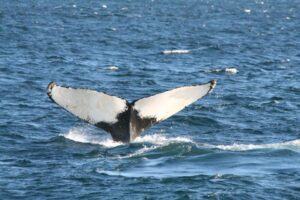
Digital aerial surveys collect data through still and video imagery on a variety of wildlife (including birds, marine mammals, sea turtles, and fish), as well as anthropogenic activities (for example, vessels and marine debris). Because collected images are processed and analyzed post-survey, digital aerial surveys can be flown at faster speeds and higher altitudes than traditional visual aerial surveys, making them safer for human operators while causing less disturbance to the animals that are surveyed.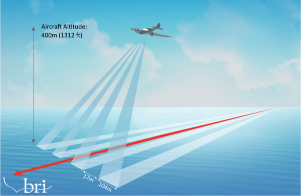
These digital aerial surveys are often used to obtain ecological baseline data to inform siting of offshore wind projects, as well as potential interactions between projects and wildlife. BRI is working with the Bureau of Ocean Energy Management (BOEM), which oversees federal offshore wind projects, to manage digital aerial surveys in the Gulf of Maine Wind Energy Area and assist with data processing and reporting.
Unoccupied Aerial Vehicle (UAV) Telemetry and Visual Surveys.
Use of UAVs, also known as drones, is becoming an established method for surveying and collecting data on wildlife. One emerging capability of UAVs is wildlife radio telemetry. Radio telemetry is an effective method for tracking animals too small to carry GPS loggers, but topography often limits how far telemetry signals can travel or pose considerable safety concerns. Wildlife telemetry with UAVs helps to overcome those challenges. With the Freefly Astro Drone, BRI offers UAV radio tracking and imaging services for a variety of taxa, including bats. BRI can now track up to 40 bat individuals simultaneously, accurately determining an individual position to 35m. Ground truthing by foot can then further improve this accuracy. Switching out the telemetry payload allows the use of high-resolution cameras, including thermal imaging, for a wide range of biological monitoring applications. The Freefly Astro Drone meets the Department of Interiors compliance requirements for all drones using federal funding being 100% US-made, allowing BRI to provide drone solutions to our State and Federal partners.
Related Links:
Digital Aerial Surveys
Game Cameras
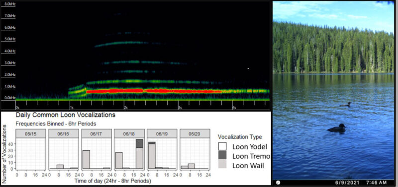
 BRI frequently utilizes game cameras and other remote sensing equipment to conduct wildlife inventory surveys. Effective wildlife surveys, even in complicated circumstances and complex environments, evaluate species’ presence to assess any potential risk. BRI utilizes cameras for Canada Lynx winter tracking surveys as well as for loon studies that seek to conserve loon populations across the Northern Hemisphere. These projects contribute to understanding basic ecology and strive to unravel the impacts of ecological stressors and how they can be lessened.
Trail cameras offer site level disturbance documentation, and paired with nest cameras, impacts of recreation or weather events can be compared. Additionally, the use of autonomous recording units can track daily occupancy of nesting birds over months between equipment servicing events. Data from cameras can then be compared to occupancy data to further investigate disturbance or predation events for nesting birds.
Additional benefits include:
Photo Credits: Header photo © Tim Divol; Humpback whale fluke © Julia Stepanuk; Aerial Survey Diagram © BRI; Lynx © BRI