BRI Studies: Movement and Tracking
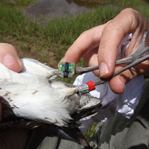
Tracking wildlife offers insight into movements and habitat usage, providing scientists valuable information about the challenges animals face on breeding and wintering grounds and along migration routes, and how decision makers can act to protect them from threats including contaminants and habitat loss. Using a variety of technologies, BRI tracks birds and mammals across all our programs, from capture and the application of transmitters through collection and analysis of data.
What We Learn from Tracking

Tracking individuals details the local movements and seasonal migrations of wildlife and often provides critical insights into animal behaviors rarely achievable using other methods. With this kind of information, BRI researchers can describe the phenology of movement and identify migratory routes and connect specific breeding or wintering destinations.
Besides location, tracking technologies can also provide information about an individual’s immediate environment, such as temperature or altitude, allowing the identification of ecological attributes of preferred habitats.
Satellite Transmitters

Satellite transmitters can be attached externally to a bird or implanted under its skin or in its body cavity under general anesthesia. BRI’s veterinary team routinely implants animals with a variety of transmitters.
Satellite transmitters regularly send data about birds’ precise locations to the Argos Data Collection and Location System aboard NOAA weather satellites. Data are sent electronically to scientists, who use the information to learn more about the distribution of bird populations, their year-round movements, and how factors such as oil spills, disease, contamination, and even the seasonal availability of food may affect the animals.
BRI uses satellite telemetry to track:
Geolocators

Global Location Sensing (GLS) tags are lightweight, non-invasive tracking devices based on GPS technology. Sensing ambient light levels to calculate sunrise, sunset, and length of day, the tags record birds’ latitude and longitude. Because GLS tags are archival and do not transmit data, scientists must recapture tagged animals to download data about their movements. GLS tags are best used on animals likely to return to the exact location in successive years.
BRI uses geolocators to track:
Songbirds:
Wetland Birds:
Nanotags

Nanotags are also small, high-frequency tags. Several nanotags deployed at once can be set to emit the same frequency but make slightly different sounds, which the receiver’s computer can discern. Biologists now place nanotag receivers on towers as a way to monitor the movements of migratory birds both at stopover sites and along their routes of travel. A nationwide network alerts researchers when birds they have tagged pass by towers.
BRI uses nanotags to track:
Marine Birds and Small Raptors:
- Migrating Shorebirds
- Merlins
Photo Credits: Header photo © Pavel Aleynikov-iStock. Study subjects: Northern Waterthrush © Ken Archer; Leach’s Storm Petrel © Creative Commons-dmore10; Merlin © Ken Wright; Yellow-billed Loon © BRI-Carrie Gray; Yellow perch © Creative Commons-Andy Camper; Northern long-eared bat © Merlin D. Tuttle, Bat Conservation International (www.batcon.org). BRI Lab © BRI.


