Mid-Atlantic Basline: Analytical Studies
We use several different approaches for presenting results in this study, ranging from simple maps depicting raw observation points, to more complex analyses that use these raw data in addition to remotely sensed habitat characteristics to model predicted abundances of wildlife. Understanding each analytical method and its limitations is essential to appropriately interpret maps, figures, and other analyses.
For more information, see Chapters 1, 11, 12, 15, 16, 17, 18, 19, 20, 21, 22, 23, and 24 in the technical report.
Raw Observation Data

Example A
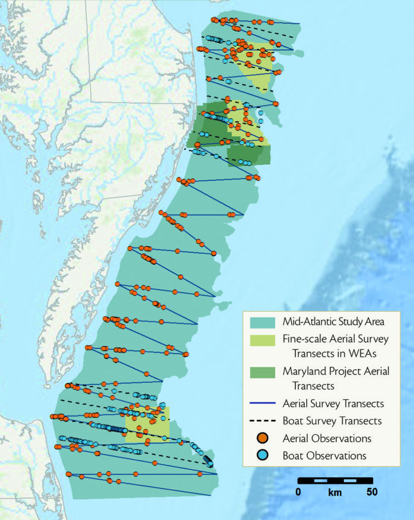
In rare instances, we simply map locations of wildlife observations without additional analyses. This is straightforward, but has limitations. There are known biases in raw survey data that make it difficult to reliably compare values across space and time or between species. Because of these limitations, we only present raw survey data when there were insufficient observations to support approaches that address these sources of error (e.g., for observations of baleen whales). This map shows a subset of data for the Northern Gannet.
Persistent Hotspots of Abundance

Example B
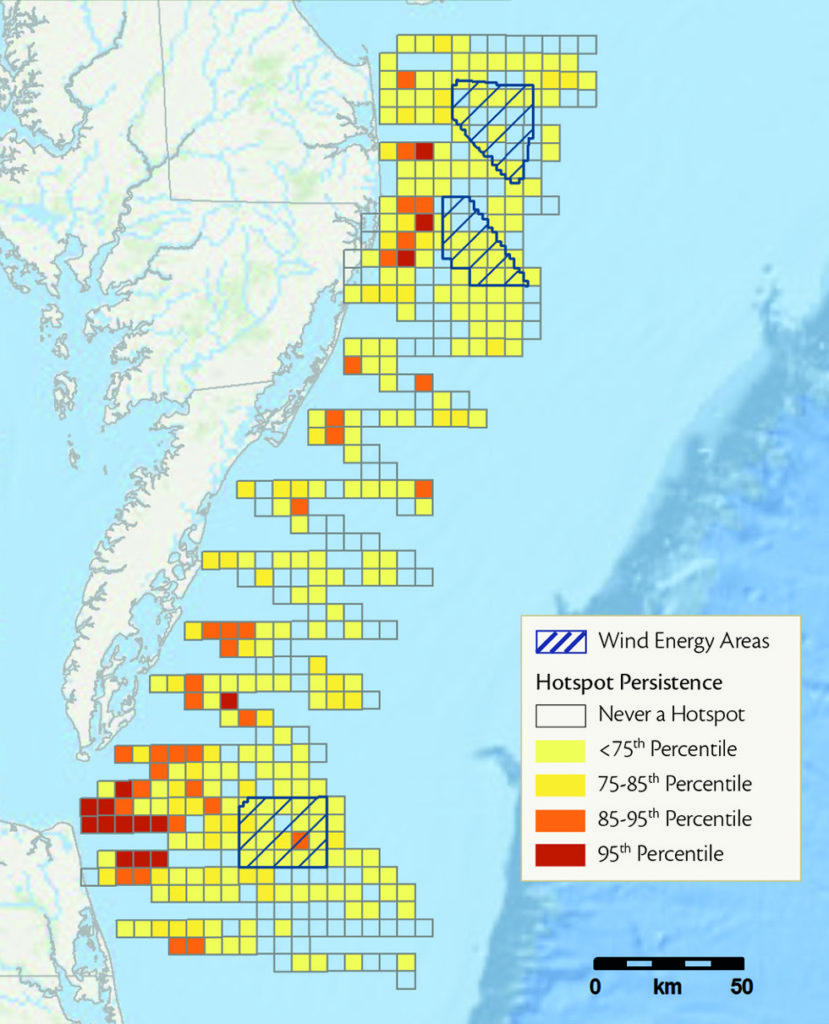
Persistent hotspots are locations where animals were most often found in large numbers relative to their typical distribution patterns. These areas likely provide important habitat for activities such as foraging or roosting. We grouped survey observations into grid cells (lease blocks defined by the Bureau of Ocean Energy Management for offshore development) and standardized counts by survey effort in each lease block. Blocks with the largest values within each survey were labeled as survey-specific hotspots; those repeatedly identified as hotspots during the two years of surveys were called “persistent” hotspots. We combined boat and aerial survey data for lease blocks that were surveyed by both methods, weighing each dataset to address differences between survey methods. The method that detected or identified the animal at the highest rate was given more weight.
Several limitations should be noted. First, hotspot maps do not indicate the full range of species’ habitat use in the mid-Atlantic; hotspots may occur in areas that were not surveyed. Second, individual grid cell “persistence” values should be interpreted with caution, as this analysis was to identify regional patterns.
This map shows data for the Northern Gannet.
Predictive Models

Example C
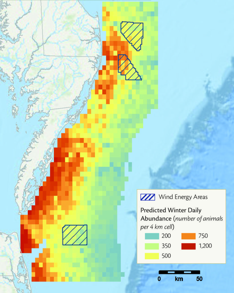
Several statistical modeling approaches are used in this study, including generalized linear models (GLMs) and generalized additive models (GAMs). These are frequently used in ecological research and can incorporate environmental data (covariates), effort corrections, and observation biases into their structure. These approaches are used to make predictions about where animals occur and what environmental factors influence their distribution or abundance.
Generalized Linear Models: Seabirds Project collaborators at North Carolina State University developed a a novel multi-species approach for estimating seabird abundance and distributions from the boat survey data. This model estimates detection as well as abundance parameters for each species, and shares information across species to allow for inferences about species with too few observations to analyze separately. Building on this model, remotely collected environmental data were incorporated into the hierarchical modeling structure to develop geospatial models that predict seabird abundance throughout the study area by season.
Generalized Additive Models: Cetaceans and Sea Turtles GAMs are extensions of GLMs that use smoothing functions to improve model fit. These models can be useful for situations with complex nonlinear relationships between predictor and response variables. Collaborators at Duke University developed GAMs with remotely collected environmental data to predict seasonal sea turtle densities and Bottlenose Dolphin pod densitites throughout the study area.
This map shows a subset of data for the Northern Gannet
Analysis of Telemetry Data

Example D
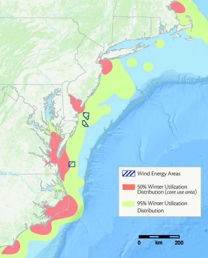
Satellite telemetry provides data on locations and movements of individual animals, which can be aggregated to identify species-specific patterns in habitat use and movement behaviors. Random samples of data points were pooled to create composite utilization distribution maps for all wintering individuals for each species. These maps show estimated core use areas, where tagged birds spent the majority (>50%) of their time, and utilization distributions, in which birds spent most (>95%) of their time.
We also used state-space models to identify detailed behavioral patterns from Northern Gannet tracking data and identify the environmental conditions correlated with foraging in this species.
Telemetry data are part of several longer term collaborative research projects with multiple funders, including satellite tracking studies of Northern Gannets, Red-throated Loons, and Surf Scoters in the mid-Atlantic. The results presented in these pages should be considered preliminary. This map shows a subset of data for the Northern Gannet.
Temporal Variation in Relative Abundance

Bar charts were developed to summarize temporal patterns of relative abundance for species or taxonomic groups in the study area. For each survey method, we summed effort-corrected total counts of individuals by two-month time period, so each period included data from two to four surveys. Boat (green, left) and aerial (orange, right) bars were placed side by side to illustrate differences in detection and/or identification between the two survey methods. Larger bars represent higher effort-corrected counts of a species or group. Relative bar sizes are comparable among individual species, but not between species and broader taxonomic groups, as species and group percentiles were calculated separately.
References
- Burnham KP, Anderson DR (1984) The need for distance data in transect counts. Journal of Wildlife Management 48:1248–1254
- Gardner B, Sullivan PJ, Epperly S, Morreale SJ (2008) Hierarchical modeling of bycatch rates of sea turtles in the western North Atlantic. Endangered Species Research 5:279–289. doi: 10.3354/ esr00105
- Guisan A, Edwards Jr TC, Hastie T (2002) Generalized linear and generalized additive models in studies of species distributions: setting the scene. Ecological Modelling 157:89–100
- Hastie TJ, Tibshirani R (1990) Generalized additive models. Statistical Science doi: 10.1016/j.csda.2010.05.004
Photo Credits: Header photo © BRI-Tim Divoll. Study Subjects: Northern long-eared bat © Bat Conservation International; Eastern small-footed bat © BRI-Jonathan Fiely; Indiana bat © BRI-Jonathan Fiely, River otter © iStock; Mink © BRI-Jonathan Fiely; Harbor seal © Sharon Fiedler. In the field © BRI; Banded bat © BRI- Jonathan Fiely; Tracking © BRI-Dave Yates; Otter family © BRI- Dave Yates, Bat cave © BRI.


